


ABOUT DIGITAL TWINS
What is a spatial digital twin?
A spatial digital twin is a dynamic, location-based digital model of real-world assets, systems, or environments.
Unlike static models, spatial digital twins evolve to reflect ongoing changes in the built and natural world by integrating geospatial context with both live and historic data.
While the concept of digital twins originated in manufacturing to model equipment and production systems, spatial digital twins stand out because they anchor all data to geographic location. This spatial foundation enables integration of extremely diverse information sources—maps, satellite imagery, 3D building models, IoT sensor data, and operational systems—within a unified geographic framework.
By positioning data in relation to where things physically exist and interact, spatial digital twins provide excellent context for infrastructure planning, environmental management, and operational decisions. This makes them particularly valuable for applications such as smart cities, urban infrastructure, climate resilience, and natural resource management, and in turn help people to better understand and manage resources and communities over time.
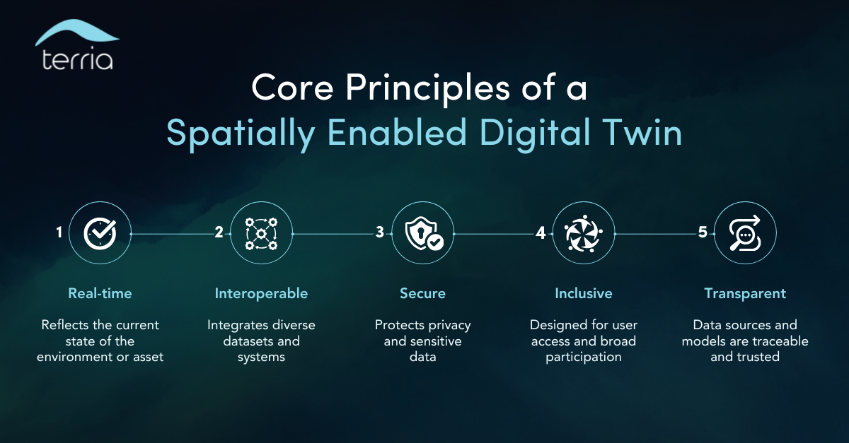
Standards and principles
According to the ANZLIC Principles for Spatially Enabled Digital Twins, effective implementations adhere to five core requirements:
Real-time. Reflects current state of physical assets or environments through continuous data synchronization.
Interoperable. Integrates diverse datasets and systems across agencies using standardized protocols.
Privacy-preserving and secure. Protects privacy and sensitive data through appropriate access controls.
Inclusive. Designed for broad user access without requiring specialized technical expertise.
Transparent. Data sources, processing methods, and model assumptions are documented and traceable.
These principles provide a framework for organizations and governments to implement spatial digital twins that support effective planning, build stakeholder trust, and address challenges including climate risk assessment and infrastructure management.
Technical foundation for successful data integration
Spatial digital twins integrate location-based data from multiple sources to support infrastructure planning, environmental management, and operational decision-making. The technical challenge lies in federating data across organizational boundaries while maintaining data governance and authority, and integrating diverse data formats into a unified, accessible interface.
Effective implementations address this through:
Federated data architectures. Data remains with custodian organizations and is accessed through standardized web services rather than centralized warehouses.
Open standards implementation. OGC web services (WMS, WFS) and metadata protocols enable interoperability across different systems.
Real-time data integration. IoT sensors, environmental monitoring, and operational systems feed current conditions into spatial context.
Multi-format support. Integration of 3D building models, terrain data, cadastral records, and time-series datasets.
This approach enables spatial digital twins to provide unified access to infrastructure networks, real-time sensor data, building information models, planning datasets, and environmental projections. These integrated datasets support analysis of spatial relationships between physical assets and operational systems for applications ranging from urban planning to disaster resilience.
What can you use a spatial digital twin for?
Infrastructure & urban planning
Overlay 3D models (e.g. BIM, FBX) with live geospatial data to simulate costs, test feasibility, and reduce planning risk for major projects, from rail networks to renewable energy zones.

Smart cities & strategic planning
Support smarter, more connected cities by visualising urban systems, traffic flows, energy infrastructure, and environmental data in a single, intuitive platform.

Community engagement & visualisation
Use web-based spatial visualisations to simplify complex data and make public consultation more inclusive and effective.
Climate risk & scenario modelling
Model flood zones, heat stress, or bushfire risk by combining real-time and predictive spatial data to support disaster resilience and mitigation planning.

Cross-agency collaboration
Break down silos and bring stakeholders together with a shared, real-time source of truth, perfect for large-scale, multi-agency infrastructure programs.
Where does Terria fit in?
Terria, originally developed at CSIRO (Commonwealth Scientific and Industrial Research Organisation, Australia's national science agency), is a spatial digital twin platform for governments, infrastructure consultants, environmental teams, and more.
Built on an open-source core, the Terria platform is a hosted, plug-and-play version of the accessible, in-browser digital twin visualizer used by millions for over a decade.
Platform characteristics:
Open standards. Implements OGC Web Map Service (WMS), Web Feature Service (WFS), and Catalogue Service for the Web (CSW) for data interoperability.
Government deployments. Provides technical foundation for systems such as the Tokyo Digital Twin and Digital Twin Victoria.
Multi-format data integration. Supports diverse geospatial formats including 3D tiles, time-series sensor data, and Building Information Models.
Web-based access. Browser-based interface requiring no specialized software installation for end users.
Terria enables organizations to federate data from multiple sources, create interactive spatial visualizations, and support decision-making workflows ranging from climate adaptation to construction oversight.


Frequently asked questions
-
Digital twins can represent any physical system from manufacturing equipment to building systems. Spatial digital twins specifically integrate geospatial context, anchoring data to real-world locations. This makes them particularly suited for infrastructure projects, environmental monitoring, urban planning, and land management applications where location relationships are fundamental to understanding system behavior.
-
Real-time sensor integration enhances spatial digital twin capabilities but is not required. Many implementations begin by federating existing datasets including cadastral records, infrastructure plans, satellite imagery, and environmental monitoring data. Sensor networks can be added incrementally as implementation matures and specific monitoring requirements are identified.
-
Spatial digital twin platforms typically implement federated data architectures rather than centralized data warehouses. Data remains with custodian organizations and is accessed through standardized web services (such as OGC WMS/WFS). This approach maintains data governance, reduces duplication, and enables organizations to update their authoritative datasets independently while making them accessible through the spatial digital twin interface.
-
Spatial digital twins should enhance your existing investments. For example, Terria federates data from Esri services, CAD files, databases, and other systems into one accessible view—without requiring data migration or changing your current workflows. Digital twins serve as the collaboration and visualization layer that makes your existing spatial data accessible organisation-wide.
References and standards
ANZLIC (2021). Principles for Spatially Enabled Digital Twins
Standards Australia (2023). Digital Twin White Paper
Digital Twin Victoria (Accessed: 2025). DVT Platform
Centre for Digital Built Britain (2018). Gemini Principles
FrontierSI (Accessed: 2025). Digital Earth Australia (DEA)

Take your spatial project to the next dimension
See how teams like yours are building digital twins that engage stakeholders and accelerate decisions.